America’s Lighthouse
OBX, where coastal legends are born – Part 4 – Hatteras Island, Stop 1
… Estimated reading time: 6 minutes – SBFL 18* – PLANNING TO VISIT – On my last post, I talked about a walking waterway. This time, how about talking about a candy-striped lighthouse that also walked? These are some of the many fascinating legends of the Outer Banks.
After leaving our boat Life’s AOK in Elizabeth City, North Carolina, our planning for our 320-mile land excursion southward on the Outer Banks (OBX) barrier islands continues. With the mighty Atlantic Sea on our left and the extensive inland waters of the Albemarle and Pamlico Sounds on our right, we planned to visit the Northern Islands. After that came Roanoke Island with all its mystery. In order to reach our next island stop, Hatteras, we will go through the Oregon Inlet using the Bonner Bridge.
Our inspiration for this trip, Dorothea and Stuart E. Jones in their 1958 National Geographic article titled, “Slow Boat to Florida,*” hence the title of this series, crossed the Oregon Inlet by ferryboat, with fishermen and vacationers.
When the 50 miles of Hatteras Island stretched ahead, long before they reached the villages of the picturesque settlements, they saw the black-and-white tower of the Cape Hatteras Light.
Historical Cape Hatteras Lighthouse
There are five lighthouses on OBX’s chain of barrier islands, all having a very rich history. Starting at the north of the barrier island chain are the Currituck Beach Lighthouse, Roanoke Marshes Lighthouse, and Bodie Island Lighthouse. All three are close enough that they can be visited on the same day. The last two lighthouses are the Cape Hatteras Lighthouse and Ocracoke Island Lighthouse; both can be visited the following day.
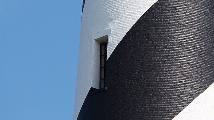
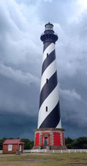
Cape Hatteras Lighthouse, near the village of Buxton, enjoys the distinction of being the tallest lighthouse in the country and one of the most recognized lighthouses in the world thanks to its pattern of black and white candy cane stripes.
The fully-functioning Cape Hatteras lighthouse still flashes a nightly beacon that rotates every 7.5 seconds and can be seen up to 20 miles out to sea. Chances are, if you are staying in the villages of Avon or Buxton and you look closely from the deck of your vacation rental home, you might be able to catch the rotation of the beam of light as it circles Hatteras Island.
US National Park Service.
©Mike Litwin
US National Park Service.
©Mike Litwin
US National Park Service.
The interesting story of the lighthouse reveals the battle with the effects of the Atlantic Ocean and the struggle of human knowledge and human ingenuity to find solutions to problems posed by mother nature. The first version of the Cape Hatteras Lighthouse was completed in 1803. However, from the first day of service it was already considered poorly constructed. That was because at only 90 feet, the beacon’s reach and visibility were simply inadequate. In 1854, the original lighthouse was renovated to stand 150 feet tall, and a Fresnel lens, one of the best at the time, was installed. Unfortunately, this did little good as well, as the lighthouse, which had been constructed out of sandstone, continued to get cracks, and an entirely new lighthouse was recommended.
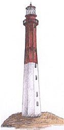
Along the way, according to legend, during the design process of the new lighthouse, an engineer in charge of the lighthouse’s design had originally intended to give it a black diamond print, as an indication of the dangerous Diamond Shoals it bordered. Instead, the engineer accidentally mixed up the plans, and Cape Lookout’s lighthouse now sports the black diamond design. Hatteras Island’s lighthouse received the black and white candy cane stripes instead that lasted to our day.
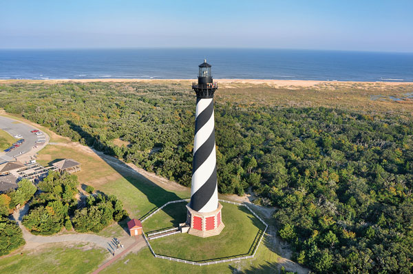
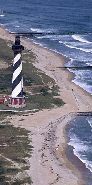
The new Cape Hatteras lighthouse, the one that stands today, was activated in December 1870. Towering at 210 ft. and located 1,500 ft. from the water’s edge. It served as an imperative navigational aid for ships for decades.
The Jones back, in 1958, huffed, puffed and spiraled up 269 steps to reach the housing of the light. From the top, 191 feet above ground, they looked down upon a fleet of wrecked vessels jutting starkly through sand and surf. I think those ghostly wrecks may no longer be there.
Virtual Tour: Today, if you visit it and if you have enough energy, committing to climbing up its 269 steps, a gorgeous coastal view will be your reward.
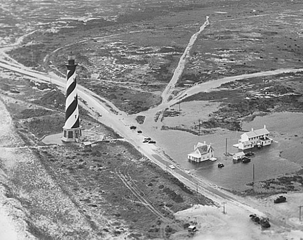
Comprising 1,250,000 bricks with an iron infrastructure, the lighthouse has withstood generations of hurricanes with minimal damage. However, one weather phenomenon that mother nature posed even the lighthouse could not withstand, erosion. Storm-driven tides completely washed over Hatteras Island, eroding sand from the ocean side of the island and depositing it on the sound side. This process has caused the gradual westward migration of the Outer Banks for at least the past 10,000 years. This erosion left the lighthouse just 50-120 feet from the ocean’s edge and almost certain destruction.
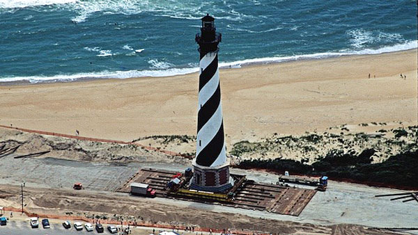
In the summer of 1999, after a year of preparation, the Cape Hatteras Light was moved from its original location 1,500 ft. back into Buxton Woods to its present location.
US National Park Service.
Yes, a 210 ft., 12-story high tower was literally moved on a 2,900 ft. journey, reaching its latest home in 23 days (including 2 days when there was no forward progress) on July 9, 1999.
Well, that’s it for now. Stay well. I hope to say hello to you if you spot my boat, Life’s AOK, in one of the locations that I’m hoping to visit in 2022, that is, if whatever the latest version of Coronavirus permits us.
I bid you Fair Winds and Following Seas.

Cover Photo: Closeup of Cape Hatteras Lighthouse. Photo courtesy of US National Park service.
5 things I learned
- The Cape Hatteras Lighthouse Keepers: When it first started its operation the staff of the Cape Hatteras Lighthouse consisted of a Principal Keeper and two Assistant Keepers. The keepers did not live in the lighthouse but, when they were on duty, they would be found in the watch room at the top of the tower. Originally, the Lighthouse Board provided housing, staple foods, medicine, and a salary up to $800/yr. After the 1880s, keepers wore dark blue wool dress uniforms or fatigues.
They worked at the lighthouse performing maintenance, repair, and administrative duties. Each keeper was required to stand a four hour watch during the night. The time of these watches alternated daily from keeper to keeper. On one day, the Principal Keeper might take the 8 pm to midnight watch, the 1st Assistant Keeper would take the midnight to 4 am watch, and the 2nd Assistant Keeper would take the 4 to 8 am watch. The following night the Principal Keeper would take the midnight to 4 am watch, etc, etc. The keeper on watch at the end of the night would be responsible for all morning maintenance of the lamp and lens to prepare them for the upcoming night.
- Starting in 1854, in addition to the lighthouses, the sholes of North Carolina were marked with lightships anchored at the shoals. The lightships—vessels with and without a crew — were deemed impractical because of hurricanes. They eventually were phased out.
- The interesting Shipwrecks Of North Carolina Map: Cape Hatteras And The Outer Banks shows the locations of over three hundred shipwrecks along the area known as “The Graveyard of the Atlantic.” During the 1800’s so many ships were lost along these shores that Congress established the United States Life-Saving Service to patrol the beaches and rescue crews from ships which were in trouble.
- The first known lighthouse was the Pharos of Alexandria, Egypt. Ptolemy I and his son Ptolemy II constructed it between 300 and 280 B.C. It stood about 450 feet high. This lighthouse was one of the Seven Wonders of the Ancient World. It was destroyed in stages by invaders and earthquakes, being destroyed in the 1300s. – See United States Lighthouse Society
- See below the 227-year journey of Cape Hatterst lighthoue.
2 things I recommend
- If you have time to visit only one lighthouse, consider visiting the Cape Hatteras Lighthouse.
- Try Holiday Recipes from the Outer Banks, North Carolina
How easy?

227-year journey of Cape Hatteras Lighhouse
Its journey started in 1803. Due to erosion it was moved in 1999. It was moved using horizontally mounted hydraulic jacks which pushed the tower along a track system in 5-foot increments. After the tower was pushed approximately 5 feet, the jacks were retracted and reset along the grid beams.
| 1794 | The first tower is authorized by the U.S. Congress. |
| 1803 | The first tower is completed. It stood 90 feet tall, was built of sandstone, and used oil lamps to light the beacon. |
| 1854 | Modifications included raising the tower to 150 ft. and installing a new first-order Fresnel lens that utilized prisms and focusing lenses to concentrate the light from an oil-fired flame into a powerful beacon. |
| 1861 | Confederate forces try to destroy the tower but were prevented by the Union forces. Confederates take the Fresnel lens with them. |
| 1862 | The light shines again but extensive repairs are needed and studies show it would be less costly to replace the tower with a new tower. |
| 1867 | $75,000 appropriated by Congress for a new lighthouse. Final cost $167.500. |
| 1868 | Construction of the second tower begins. |
| 1870 | Construction completed. The first-order Fresnel lens from the 1803 lighthouse is transferred to the new tower. |
| 1873 | Black and white daymark striping was ordered by the Lighthouse Board. |
1893 | 1400 to 1500 feet from the shoreline. |
| 1913 | Illuminant changed to incandescent oil vapor lamps. |
1919 | Less than 300 feet from the shoreline! |
| 1930 | First groins installed. |
1933 | Less than 100 feet from the shoreline! More groins were installed. |
| 1934 | Lamps electrified. |
| 1935 | Erosion threatened the base of the tower as waves washed against it. Lighthouse abandoned and replaced by skeleton steel structure a mile northwest of the brick tower. |
| 1936 | Ownership transferred to the U.S. National Park Service (NPS.) Civilian Conservation Corps (CCC) began building sand dunes along the Outer Banks to aid in erosion control. |
| 1939 | CCC guides give tours of lighthouse. |
| 1942–45 | Leased to US Coast Guard for use as an observation tower during WWII. |
1945 | 500 to 900 feet from the shoreline! |
| 1946 | Fresnel lens apparatus vandalized. |
| 1949 | Fresnel lens was removed from the tower, but the pedestal and clockwork were left in place. |
| 1950 | Eroded sand stopped naturally and control work by CCC made it possible to transfer the beacon back to the brick tower. |
| 1950–51 | North Carolina Highway 12 was constructed with ferry service at Oregon Inlet. |
| 1953 | Cape Hatteras National Seashore was established. Lighthouse opened to the public. |
| 1960 | Unknown quantities of sand pumped onto the shoreline. |
| 1972 | 800,000-candlepower beacon installed, consisting of a rotary beacon with two 1000-watt lamps. Flashes every 7.5 seconds. This is the beacon that is present today. |
1975 | 175 feet from the shoreline! Structural cracks in the tower led to its closing to the public. |
1980 | 50 to 70 feet from the shoreline! |
| 1981 | Experimental artificial seagrass is placed on the shoreline. “Save the Lighthouse Committee” was formed by US Senator Helms, Governor Hunt of North Carolina, and others. |
| 1984–93 | A 40-pound chunk of metal window trim fell to the ground, leading to the lighthouse being closed to the public again. |
| 1987 | NPS requests an independent study to save the lighthouse. |
| 1988 | Independent study recommends relocation. |
| 1989 | NPS announces the decision to move the lighthouse when the risk of leaving it outweighed the risk of moving it. |
| 1990 | Restoration of the tower begins. |
| 1993 | Repairs are completed and the lighthouse again opens to the public. |
| 1994 | Exterior repainting completed. NPS superintendent declares risk of leaving the lighthouse now outweighs the risk of moving it. |
| 1997 | A report was released endorsing immediate relocation. |
| 1999 | Oil house, two cisterns, double keepers’ quarters, and principal keeper’s quarters move to the new site in March. Later, from June 17, 1999 to July 9, 1999 (23 Days) the lighthouse moved 2900 ft, moving it 1500 ft back from the ocean. |
| 2000 | Lighthouse reopens for climbing. |
| 2001 | Lighthouse closes to the public on June 11th due to repairs needing to be done on the stairs. |
| 2002 | Painted in December. |
| 2003 | On April 18th, the lighthouse reopens to the public. |
| 2006 | The pedestal and clockwork were removed from the tower and reunited with the lens at the Graveyard of the Atlantic Museum in Hatteras, NC, which is 10 miles southwest of the lighthouse. |
| 2014 | Lighthouse repainting is done during the spring and summer months. |
*SBFL stands for Slow Boat to Florida. It is a series of my blog posts, which started with a posting that had the same title. Each numbered heading has two parts. The first is “Planned or Planning to visit,” and when we visit the planned location, a “Visited” label appears at the beginning, next to SBFL. The essence of this series is not to seek new lands and exotic cultures. Rather, it is to cover our journey of discovery (hence the title of our blog Trips Of Discovery) that has to do with seeing with a new eye the coastal locations of the Atlantic Intracoastal Waterway (ICW) where present-day America started to flourish. The SBFL series represents part travel, part current and historical anthropological highlights of selected locations and coastal life. We’re comparing then and now, based on observations made by Dorothea and Stuart E. Jones in their 1958 National Geographic article titled, “Slow Boat to Florida” and a 1973 book published by National Geographic, titled America’s Inland Waterway (ICW) by Allan C. Fisher, Jr. We also take a brief look at the history of the locations that I am writing about. Finally, we bundle it up with our observations during our actual visits to the locations and our interviews with local residents. Think of it as a modest time capsule of past and present. My wife and I hope that you, too, can visit the locations that we cover, whether with your boat or by car. However, if that is not in your bucket list to do, enjoy reading our plans and actual visits as armchair travelers anyway. Also, we would love to hear from you on any current or past insights about the locations that I am visiting. Drop me a note, will you?